"Raging
Waves and Roaring Winds: Sindh Coastal Areas, including Karachi, Brace for
Cyclone Biparjoy"
Introduction
In recent days, concerns have been raised as Cyclone Biparjoy
strengthens and transforms into an Extremely Severe Cyclonic Storm (ESCS). The
authorities are on high alert as the cyclone is expected to make landfall in
Sindh's coastal areas, including Karachi, on June 13 (Tuesday). In this
article, we aim to provide comprehensive information and guidance to ensure the
safety of residents and mitigate the potential risks associated with this
cyclone.
Understanding the Cyclone's Intensity and Impact
The National Disaster Management Authority (NDMA) and the
Pakistan Meteorological Department (PMD) have been closely monitoring the
cyclone's development. According to the NDMA, the cyclone is likely to
intensify further in the next 24 hours, bringing strong winds, torrential
rains, and the possibility of floods to the coastal areas of Sindh.
Precautionary
Measures and Awareness Campaign
Recognizing the potential risks associated with Cyclone
Biparjoy, the NDMA has directed the authorities to launch an awareness campaign
in the local language to inform residents of the coastal areas about the
weather conditions. This campaign aims to advise people against visiting the
shorelines and emphasize the importance of following instructions from local
authorities during emergency situations.
Moreover, the NDMA has specifically advised fishermen to
avoid boating in the open sea and cooperate with local authorities. These
measures are crucial to ensuring the safety of individuals and minimizing the
chances of accidents or unforeseen incidents.
Projected
Path and Expected Weather Conditions
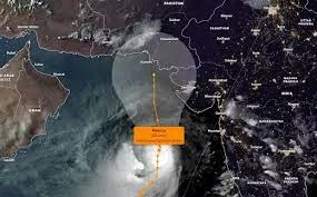
According to the PMD's cyclone warning center, the ESCS Biparjoy is likely to track further northward until the morning of June 14. Subsequently, it is expected to recurve northeastward and make landfall between Keti Bandar (Southeast Sindh) and the Indian Gujarat coast on June 15 afternoon as a Very Severe Cyclonic Storm (VSCS).
Impact and
Safety Precautions
The potential impacts of Cyclone Biparjoy are significant, and residents in the affected areas must be prepared. Widespread wind-dust/thunderstorm rain, with the likelihood of heavy to extremely heavy falls, is expected in districts such as Thatta, Sujawal, Badin, Tharparker, and Umerkot during June 13-17. Karachi, Hyderabad, Tando Muhammad Khan, Tando Allayar, and Mirpurkhas districts may experience dust/thunderstorm-rain with a few heavy falls and squally winds from June 13 to 16.
Given the intensity of the cyclone, it is crucial to take necessary safety precautions. Loose and vulnerable structures, such as katcha houses, may be prone to damage from the high-intensity winds. Furthermore, a storm surge of 3-3.5 meters (8-12 feet) is expected at the land falling point, which highlights the need for coastal residents to exercise caution and stay away from the sea during this period. Fishermen are strongly advised not to venture into the open sea until the cyclone subsides by June 17. The Arabian Sea conditions may become very rough with high tides along the coast, posing significant risks to maritime activities.
Impact on
Flight Operations
The inclement weather conditions have impacted flight
operations across the country. Several flights have been diverted or delayed
due to the cyclone. Passengers are advised to check with their respective
airlines for updated information regarding their flights.
Conclusion
As Cyclone Biparjoy approaches Sindh's coastal areas, it is
crucial for residents to prioritize their safety and heed the warnings and
instructions from authorities. This article aimed to provide comprehensive
information regarding the cyclone, its projected path, expected weather
conditions, and the necessary precautionary measures to be taken. By staying
informed, following safety guidelines, and cooperating with local authorities,
we can collectively mitigate the risks associated with the cyclone. Let us
prioritize the well-being of ourselves and our communities during this
challenging time.


.jpg)